


INLAND FLOOD & DROUGHT ACTIVE MONTIORING PROJECT
.png)
Building community resilience through observation
and shared memory
CEBE’s Inland Flood and Drought Active Monitoring Project (IFDAMP) engages community members in the monitoring of local flood- and drought-vulnerable sites through an easily-searchable library of flood and drought event stories and community-reported data. The project documents climate impacts and shares stories of how communities are responding to challenges brought on by flooding and drought.
The data collected by IFDAMP participants help to identify and document high-risk and repetitive damage areas and the extent and duration of flood and drought conditions, increasing our understanding of climate impacts at local and regional scales. Through integration with the National Weather Service, US Geological Survey, and other climate research entities, IFDAMP will help ground-truth inland flood and drought models, improve Regional Hazard Mitigation Plans (which are crucial for future grants and reimbursements after disasters), and help prevent personal and community property loss through more informed land use planning.

Sept. 2025 drought conditions

IFDAMP was inspired by an interactive session on local flooding at CEBE’s 2024 Climate Convergence and subsequently funded by a three-year grant from The Betterment Fund, with generous in-kind technical support from the Gulf of Maine Research Institute.
Why Is This Important?
Over the last century, Maine has warmed by over 3 degrees Fahrenheit, and our annual precipitation has increased by about 15%. The science is clear–Maine is getting warmer and wetter.
Warmer temperatures increase the likelihood and frequency of both flood and drought. Maine communities are already experiencing this–responding to extreme precipitation and flooding one year, and to extreme heat, drought, dry wells, and increased fire danger the next.
Numerous studies have shown a strong positive relationship between disaster memory and community resilience. Sharing lessons learned from past events through storytelling, photos, videos, and intergenerational interviews helps people recognize early warning signs and take protective action faster, helping bring neighbors together and build the trust and social ties needed to support one another during a crisis. Reflecting on what went wrong or right in previous disasters allows groups to update local safety plans and lower future risks.
This work is being accomplished in coalition with Androscoggin Valley Council of Governments, Androscoggin River Watershed Council, Gulf of Maine Research Institute, Oxford County Emergency Management Agency, Mount Washington Observatory, National Drought Mitigation Center, Northeastern University, Sierra Club Maine Chapter, and The Nature Conservancy in Maine.
Project Timeline
Year 1 (2025) - Project Research & Development. CEBE and the IFDAMP coalition:
-
Organized and began project coordination to develop a community-driven flood monitoring platform for western Maine.
-
Expanded partnerships beyond the original four collaborating organizations, adding five more.
-
In response to 2025’s severe drought, began to expand the scope of the project to include the collection of drought observations and stories.
-
Partnered with Dr. Damon Hall and his Environmental Capstone students at Northeastern University. Student teams worked on:
-
Educational curriculum development.
-
Inland flood communications.
-
Story map development.
-
Development of more user-friendly and affordable stream gauges.
-
-
Developed an online data portal on GMRI’s Ecosystem Investigation Network platform. The platform is live, and the data viewer and story map will be added in 2026.
-
Began developing our outreach strategy and materials.
.png)
Year 2 (2026) - Project Launch & Implementation. CEBE and the IFDAMP coalition is:
-
Continuing to fully integrate drought monitoring into the project.
-
Continuing to develop our outreach strategy and materials.
-
Conducting initial trainings and outreach; supporting data collection; and developing and implementing evaluation strategies.
-
Supporting the launch of the data viewer and story map on the EcoINet Platform (with the goal of a full launch by the end of 2026).
-
Continuing curriculum development to support the participation of middle- and high-school teachers and students.
Year 3 (2027) - Project Evaluation, Adjustment, and Growth. We plan to:
-
Conduct rigorous project evaluation and review of goals.
-
Continue project development based on findings.
-
Provide ongoing support for continued project expansion and enhancement.
-
Develop a comprehensive strategic plan to ensure IFDAMP’s ongoing effectiveness and value to the communities it serves.
If you or your group are interested in learning more about this project or how you can get involved, please click here.
Check out our IFDAMP brochure here!
During the 24-25 school year, Telstar High School's Environmental Policy Class collaborated with CEBE to explore ways to raise awareness of the increasing threat of inland flooding in their region, and to develop new ways for community members to engage in local flood monitoring and resilience efforts.
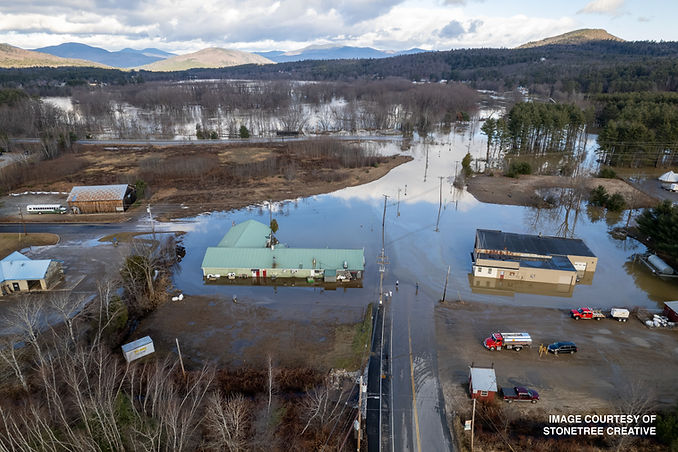
2023 flood images and drone footage were generously provided by Matthew Staglia, Stonetree Creative.

